Scioto River Sweep: September 7, 2019, 9:00 AM – 12:00 PM
Lunch, equipment and canoes provided.
Scioto River Sweep: September 7, 2019, 9:00 AM – 12:00 PM
Lunch, equipment and canoes provided.
Bellpoint Community Church Shelter
4771 OH-257, Delaware, OH 43015
In celebration of the Olentangy Watershed Alliance’s 20th Anniversary this year, we have organized a volunteer fish habitat assembling effort. OWA will be working with the Army Corps of Engineers to assemble porcupine crib fish habitat that will be placed into the Delaware Lake once finished.
Delaware Lake, Delaware State Park (source)
Sunday, April 28th, from 9-noon at 3920 U.S. Highway 23 N. Delaware, OH 43015.
In celebration of the Olentangy Watershed Alliance’s 20th Anniversary this year, we have organized a volunteer fish habitat assembling effort. OWA will be working with the Army Corps of Engineers to assemble porcupine crib fish habitat that will be placed into the Delaware Lake once finished.
Please RSVP to olentangyriverwatershed@gmail.com
Flyer below: Click for PDF
Asia Network, Guest Speaker Dr. Chris Coggins Talk: God, Mountains, and Fengshui Forests
China’s Village Watersheds as Relict Sacred Space in the Anthropocene
Date: March 7, 2019, Time 7:00- 8:00 p.m., Place: Benes A in HWCC
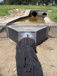
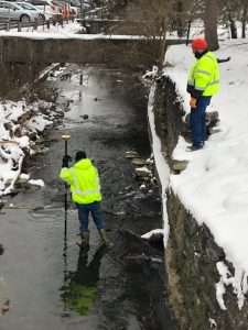
Students and faculty have been working a project to implement a storm drain net in the Delaware Run on campus. The purpose of the net will be to remove trash and green waste/debris from the Delaware Run behind Merrick on campus.
 Beginning in the Fall of 2018, Janelle Valdinger, Dr. John Krygier and I (Brianna Graber) have been cohesively working a project to implement a storm drain net in the Delaware Run, on OWU’s campus. The purpose of this project will be for Summer Science Research through Ohio Wesleyan University and for an internship with the City of Delaware. The purpose of the net will be to remove trash and green waste/debris from the Delaware Run behind Merrick on campus.

DELAWARE, Ohio – Ohio Wesleyan University student Janelle Valdinger is one of fewer than 20 undergraduate and graduate students across the country invited to participate in January in the first national Workshop on Community Geography.

DELAWARE, Ohio – Ohio Wesleyan University student Janelle Valdinger is one of fewer than 20 undergraduate and graduate students across the country invited to participate in January in the first national Workshop on Community Geography.
Valdinger, an OWU geography major, has been named a Community Geography Fellow and awarded funds to attend the two-day conference Jan. 25-26 at Georgia State University in Atlanta. According to organizers, the National Science Foundation-supported workshop will bring together 40 to 50 Community Geography Fellows, who are “academic researchers and community leaders interested in using geographic research for community development, social justice, and environmental sustainability.”
In addition to being a full-time Ohio Wesleyan student, Valdinger also is a full-time employee of the City of Delaware, where she works as a Geographic Information System (GIS) technician.
She said her main goals for the workshop include “learning new ways to use geographic research for community development, especially in other countries … and finding new ways to build a stronger, long-lasting working relationship between Ohio Wesleyan University and the City of Delaware.”
Valdinger already has helped to coordinate a joint university-city project to install three water-purifying rain gardens on OWU’s campus. She is helping now to implement a collaborative relationship that involves the city’s Department of Public Utilities hosting OWU students as interns and “developing a partnership with the OWU Summer Science Research Program where the city hires a student-intern for the summer and the university provides housing, along with faculty guidance for a research project.”
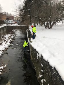
The first Ohio Wesleyan student to hold the summer research internship is junior zoology major Brianna Graber. Graber is working with the city this semester on a project to fund and install storm-drain nets to catch large waste items and prevent them from entering the Olentangy River.
While attending the Georgia conference, Valdinger will present information on the developing OWU-Delaware partnership, which currently includes eight university students working on environmental projects.
In addition, she hopes to glean information to assist with her Ohio Wesleyan departmental honors project, which focuses on mapping public utilities in Belize.
On campus, she is collaborating on the honors project with Department of Geology and Geography faculty members John Krygier, Ph.D., director of environmental studies; Nathan Amador Rowley, Ph.D.; and Ashley Allen, Ph.D., and with Jay Scheffel, assistant director of physical plant. Off campus, Valdinger is working with 2003 OWU alumnus Tim Hawthorne, Ph.D., assistant professor of GIS at the University of Central Florida.
“Not only will we be mapping utilities, but we will be providing utility locators to the local government officials in Belize,” Valdinger said. “Citizen Science will play a large role in this project, and learning (at the workshop) about what avenues other professionals have taken will help greatly in the execution of my project.”
Krygier, who was also named a Community Geography Fellow, said he is excited for Valdinger to attend the workshop and share her OWU accomplishments with scholars from across the country, and to learn how to further community engagement on campus, in Delaware, and abroad.
He also is excited by the overall potential of community geography, one of his research specialties, and its focus on engaged community work.
“It’s about creating a win-win situation for colleges and their communities,” Krygier said, “with positive impacts, research experiences, and real-world engagement between people and institutions who share many common goals.”
Learn more about the upcoming national Workshop on Community Geography at www.communitymappinglab.org/commgeog19.html and more about OWU’s geography major at www.owu.edu/geography or https://sustainability.owu.edu.
Two nest boxes and a feeder stand were recently installed in the backyard of the new Tree House SLU (small living unit) on Rowland Ave., on campus.
Two nest boxes and a feeder stand were recently installed in the backyard of the new Tree House SLU (small living unit) on Rowland Ave., on campus. Alumni Dick Tuttle and student Eva Blockstein installed the boxes and are maintaining them. The nest boxes were taken from the old Tree House SLU where they raised Carolina Chickadees and House Wrens during their stay there. The feeder stand’s top is many decades old but it has a new layer of paint.
Nest box 2 is facing the sidewalk on Rowland Ave. so students can see it as they walk to-and-from classes. Number-2’s label should cause the curious to ask, “So, where is number 1?”
Eva filled a feeder with sunflower seed and it now hangs from the feeder stand. The second feeder will be seen by veteran birds and will speed up the use of the new offerings.
For the Spring of 2018, Dr. Amador-Rowley and Dr. Allen along with student Janelle Valdinger have organized a “group independent study” course focused on creating better maps for areas of rural Tanzania through a non-profit organization called Crowd2Map.
For the Spring of 2018, Dr. Amador-Rowley and Dr. Allen along with student Janelle Valdinger have organized a “group independent study” course focused on creating better maps for areas of rural Tanzania through a non-profit organization called Crowd2Map.
No experience necessary!
You can take the class either Tuesday (Dr. Amador-Rowley) or Thursday (Dr. Allen) afternoon.
Space is limited!
Contact Dr. Rowley (nsamador@owu.edu) or Dr. Allen (alallen@owu.edu) ASAP.
Probably best if you fill out a Change-of-Schedule Form from the Registrar’s site and use that to enroll in the class.
Independent Study Description: Students will help create better maps of rural Tanzania, particularly those areas where girls are at risk of Female Genital Mutilation. Students will liaise with volunteers in Tanzania and worldwide. Adding roads and buildings from satellite images into OpenStreetMap will allow activists to better protect girls at risk of FGM and allow better delivery and monitoring of services, as well as improved navigation. After training, students will also give feedback to new mappers and assist with validation. They will liaise with community mappers on the ground and also create village level printable maps using QGIS. We will work with small communities that do not typically show up on maps. The open-source map developed in this independent study effort will be open to everyone and help better planning of services. No previous mapping experience necessary!!
It took us more than a year but we now are able to offer an ACTV (Activity Course) with sustainability content. This started as a student initiative.
For the spring of 2018, this course will be offered during the first and second module for .25 credit. Thus the course is a great add-on to your normal class load.
Please sign up for the class, and urge others to do so. We can offer additional topics (organic gardening, repair, etc.) in the future if this one flies.
The instructor is Aleks Ilik: he is an OWU grad and happens to be married to Kristina Bogdanov (Art). Aleks runs the Blue House Worm Farm in town and is currently working with students Matt Burke and Peyton Hardesty on a worm composting table at MTSO. One goal for the course is to expand this effort to OWU’s campus.
Chris Fink of HHK is listed as the instructor, but that is only because Aleks is not yet in the OWU system.
Meetings are scheduled Wednesday, noon-1 and Friday 2:10-4pm. Location TBA.
The Activity course will expand this effort, working with AVI and other folks to reduce waste on campus.
Please let us know if you have any questions!
Drones & Spatial Storytelling in Belize
Presented at the ELDAAG Fall 2018 Regional Division Meeting, Ohio Northern University
Using DJI Phantom 4 drones, we captured high-resolution imagery off the coast of Belize. This provides geospatial data to help explain observed land surface changes. Imagery gathered during the data collection process replaces outdated and low-resolution satellite imagery. We use ESRI’s Drone2Map software to process data and create orthomosaics of individual islands. These orthomosaics are used for digitizing to identify several aspects of the islands. We interviewed locals that either reside, work, or visit the islands. After analyzing the latter information, some themes include: how island boundaries have changed over the years, the effects of mangrove loss, and information on structures (seawalls, buildings, docks). All data is open to being used for the betterment of these island communities. The work has significant implications for using geospatial technologies in Belize and globally, to provide much needed local knowledge on the impacts and adaptations of these islands.
Keeping the Culture Alive: Using Representation to Combat Gentrification in Urban Communities
Presented at the ELDAAG Fall 2018 Regional Division Meeting, Ohio Northern University
This poster summarizes research done in Baltimore, Washington D.C. and San Francisco in Summer 2017. I examined the importance of urban murals and gardens as representations of real Black, Latinx, and Asian communities rather than tourist attractions. I found that many recent gentrification efforts have caused concern for these minority communities because they do not want to have to leave a place where their roots are so deeply sewn, yet tourism is important to maintain each neighborhood’s economic structure. The murals display residents’ pride and connection to their communities. Often, they depict minority leaders whose work was impactful or inspirational. The gardens show the citizen’s efforts in not only trying to stay in their communities but bettering their communities. While many of these neighborhoods are seen as run down and unwelcoming, they are actually representative of culturally rich areas at risk of being negatively impacted by gentrification.