Green Business Survey and Resource Guide

The goal of the Delaware Green Business Project is to create a Green Business Challenge for the City of Delaware in order to help local businesses to become more environmentally sustainable. An online survey and resource guide (downloadable) were created for the project.

Screen Shot 2014-11-13 at 5.33.33 AM

Photograph of historic downtown Delaware, Ohio. Photography by John Hollinger (Source)


Delaware, Ohio Green Business Survey & Resource Guide                      

Spring 2012

Sophie Kiendl, Amy Carr, John Krygier, Sean Kinghorn

Summary

The goal of the Delaware Green Business Project is to create a Green Business Challenge for the City of Delaware in order to help local businesses to become more environmentally sustainable. The Challenge will be initiated with an online survey created for the project. The survey will allow us to monitor various environmental issues related to community businesses over time, and can be connected to the Sustainability Region database. Our main objective is to decrease energy usage, water consumption and waste and improve the performance of commercial and institutional buildings and their operations. We will work with Delaware business to increase the environmentally business practices will decrease their expenditures. The Green Business Project is a business friendly project and will in no way harm participating businesses. We encourage the entire business community to join us and help create a greener community.

Methods and Results

At the beginning of the semester Dr. Krygier informed us that we would be doing class projects involving the environmental sustainability of Ohio Wesleyan University and Delaware County. We had to come up with ideas that both would add depth to the project and interested us. Amy came up with the idea of a Green Business Challenge for Delaware Businesses. The idea came from a previous project she worked on in Charleston, SC, which had the same goal of increasing greener business practices in their community. Amy and I worked with Sean Kinghorn to come up with ideas for what we would like to have involved in our green business challenge to make it effective and applicable to the Delaware County business community. We met weekly to ensure that we could provide our participants with the best possible challenge and resources to complete the challenge. We developed an online survey with 37 questions for the participants to complete with 65 points possible.

Participants will receive this message upon receiving the online survey challenge.

We have sent you the Delaware Green Business Challenge survey. The survey is meant to give you a baseline of how green your business is and an idea of what areas you can improve in. It includes 50 actions that are necessary for a greener business. Once you have completed the survey your answers are collected and your score is generated. There are a 100 points total 4 tiers of achievements. Tier 1 being the highest level of achievement. See the chart below for a breakdown of points needed for each tier.

Along with the challenge businesses will receive a Resource Guide to help green their business. Once each business has finished the challenge we will compute their scores and personally work with them on ways to better their businesses. As well businesses will receive a plaque or certificate showing the public that they have participated (in no circumstances will the businesses scores be shared with the general public, we are here to help not harm!).

See the two documents generated for this project:

  • Green Business Challenge Survey (PDF)
  • Green Business Resource Guide (PDF) (Word)

The survey is in Google Docs format and can be modified and sent to businesses if students are interested in continuing the project. The resource guide, with some updates, can also be used for future projects. Contact John Krygier for more information.

Recommendations (2012)

  1. Consult the City of Delaware Chamber of Commerce. Allow for critique and adjustment of the survey to meet the needs of Delaware businesses. With the approval and backing of the Chamber of Commerce it is possible that more businesses will want to participate in the survey and Green Challenge program. Inquire as to methods of promoting the survey and program.
  1. Consult additional local business organizations, such as Downtown Delaware. Again, allow critique and adjustment of the survey and the Green Challenge program. Inquire as to methods of promoting the survey and program.
  1. Develop educational programs on sustainable practices that are open to the public along with programs only for those that are participating in the program. The educational programs should be hosted by Ohio Wesleyan, which opens the possibility to involve students in the programs. The involvement of both the City of Delaware and Ohio Wesleyan in the program will lead to a stronger relationship between the City and the University. Reach out to the Economics Department to see if students and faculty may be interested in moving the survey, Green Challenge, and additional sustainable practices programs forward.
  1. Directly link the results of the survey to the Sustainability Region database. Institute a program to periodically resurvey businesses to track change over time and assess the impact of the programs promoting sustainable practices.


Ohio Wesleyan Salamander Habitat

A small wetlands area exists at the edge of Ohio Wesleyan’s campus, pinched between the recreational trail, US Highway 23, and OWU Athletic fields. This habitat, artificially created by the significant landscape modifications in the area over the past 100+ years, supports salamanders and other wildlife, despite poor water quality, noise, half-buried waste from an old Ohio Wesleyan dump, and garbage. This project builds on an earlier project that removed garbage from the area and provided a basic assessment of the location and animal species present.

salamanders

OWU’s Salamander Swamp                       

Fall 2013

Tiffany Green, Amy Downing, John Krygier, Sean Kinghorn, Thomas Wolber, Milagros Green, Sara Starzyx

Summary

Wildlife can thrive in even the most marginal of habitats. A small wetlands area exists at the edge of Ohio Wesleyan’s campus, pinched between the recreational trail, US Highway 23, and OWU Athletic fields. This habitat, artificially created by the significant landscape modifications in the area over the past 100+ years, supports salamanders and other wildlife, despite poor water quality, noise, half-buried waste from an old Ohio Wesleyan dump, and garbage. This project builds on an earlier project that removed garbage from the area and provided a basic assessment of the location and animal species present. Our goal for the current project is to consider the development of the area as an outdoor classroom and research location. To this end, we need to complete a more thorough assessment of animal and plants in the area, test the water (and potentially soil) and consider steps (short and long term) to enhance the habitat. Habitat enhancements may include the addition of salamander-friendly wood “houses,” invasive plant species removal, improved (but ecologically friendly) access for class and researcher access, remediation of water pollution sources, remediation of litter sources, noise reduction, etc.

Methods and Results: Fall 2012 Clean-up

The original project involved a quick assessment of the habitat, to see if any salamanders could be found, prior to a cleanup of garbage in the area. We weren’t expecting to find salamanders; therefore it came as a shock when three Eastern Red-Backed Salamanders were found, almost immediately, under rotting trees and rocks near the water. Photos were taken and later the species was identified by comparing the images to ones shown on the internet. While finding the salamanders was positive, the habitat itself was a mess. The area was filled with trash; pillows, a shower curtain, parts of a car, a tent, bottles, ceramics, cooking utensils etc. Some of the older trash dates from the time that the area was used as a dump by Ohio Wesleyan, including half-buried barrels, vehicle parts, etc. Newer trash has descended into the area from the recreation trail, US 315, and the athletic field to the south of the habitat.

Sustainability Coordinator Sean Kinghorn helped organize a day (Fall 2012) where volunteers could help remove trash from the habitat. Sean provided trash bags, gloves, and lawn shears as well as a place to dispose of the trash. The date was set in December, because by then all salamanders would be hibernating and so we would be less likely to disturb them. Trash was removed in and around the area where the three salamanders were found. All except for those pieces that were too big, or too heavy to lift. This ended up being not such a bad thing since animals seemed to be using the car parts, tires etc. as their homes. In order to clear out the area, a rudimentary path was created by utilizing fallen logs and cutting away the underbrush. By using the path to get down the steep incline, all trash from the area was cleared, and ended up filling ten trash bags. We recycled what we could. Clearing out the trash is only the first step to saving the salamanders and their habitat; there is much left that needs to be done.

Screen Shot 2014-10-21 at 6.11.22 PM

Screen Shot 2014-10-21 at 6.11.37 PM

Recommendations: Fall 2012

  1. Complete a more assessment of animal and plants in the habitat. Initiate a salamander census as the first step in assessing numbers over time. Assess salamander migration into and out of the area, if possible, and obstacles to this migration. Collaborate with OWU faculty and students who may be interested in using this habitat for research.
  2. Evaluate the water in the habitat, including sources. Test the water to evaluate any problematic pollutants.
  3. Evaluate the soil in the habitat.
  4. Evaluate noise in the habitat (primarily US 315)
  5. Create salamander friendly “houses” in the habitat
  6. Evaluate the removal of invasive species that adversely affect the area as a habitat for salamanders and other native animal species.
  7. Evaluate access to the area for class and student research purposes.
  8. Organize another trash clean up late 2013.
  9. Develop a long-term plan for habitat enhancement and use as an Ohio Wesleyan ecological research location.

Methods and Results: Fall 2013 Removal of Invasive Plant Species

Amphibians require aquatic and terrestrial habitats to complete their lifecycles, and preservation of both habitats is necessary for maintaining a steady population. A study done in 2004 showed that spotted salamanders, Jefferson’s salamander complex and smallmouth salamanders were positively associated with the amount of forest within a core zone (Porej 2004). Some invasive species thin out forests and this could have a negative impact on the salamander population found at the edge of OWU’s campus. With the help of Ohio Wesleyan student Thomas Bain, the invasive plant species most abundant within the wetland were identified. These two invasive species were amur honeysuckle (Lonicera maackii) and garlic mustard (Alliaria petiolata). Almost all plants within the wetland being studied were invasive. Because of this, it was thought that before removal of all invasive plant species could take place, an assessment of the impact this might have needed to be taken into account first.

Successful eradication efforts have generally benefited biological diversity. However, there is also evidence that, without sufficient planning, successful eradication can have unwanted and unexpected impacts on native species and ecosystems. Sometimes the eradication of an invasive species can hurt a native species. This happens if the native species has begun to use the invasive as a nesting habitat (as with the willow flycatcher and exotic saltcedar). But even when this is not the case, sometimes invaded areas are no longer able to support the growth of native plant species (Zavaleta 2001). This may be true with both amur honeysuckle and garlic mustard.

Amur honeysuckle (Lonicera maackii) tends to shade out native vegetation, particularly in the understory, they deplete soil moisture, and there have been studies that have shown that these plants increase pH levels in the soil (Hicks 2004 and Exotic honeysuckles 2013). Garlic mustard produces allelochemicals which suppress mycorrhizal fungi that most plants require for optimum growth (Garlic mustard 2013 and Alliaria petiolata 2013). So even with the removal of all the amur honeysuckle and garlic mustard from the area, native plant species may need additional help to reestablish themselves, since the soil might no longer be suitable for their growth.

These two invasive species are detrimental to salamander health. A study done in 2011 found that Amur honeysuckle affected the microclimate (temperature and humidity at ground level) of forest’s understory. Mean daily temperatures were lower in invaded plots compared to those not overrun with Amur honeysuckle. This was correlated with a decline in amphibian species richness and evenness in invaded plots (Watling 2011). Another study focusing on garlic mustard impacts was done in 2009. It was found that this plant was correlated with a diminish in prey resources of the woodland salamander (Maerz 2009).

Four plots of land within the wetland were marked off using flags. These plots were each 10 meters by 10 meters, and each pair was chosen according to how similar they were to each other. From each pair, one would have the invasive plants removed, while the other remained how it was found; acting as the control. After being marked off, the plots were carefully searched through for salamanders. Salamanders were found under rock and leaves. After finding the salamander, the disturbed rocks and leaves were placed back as close to the original location as possible.

Plot Number Number of Salamanders Found
1 3
2 4
3 2
4 4

Table 1. The number of salamanders found in each plot before invasive species were removed.

After the salamanders were found and recorded, the invasive species, amur honeysuckle (Lonicera maackii) and garlic mustard (Alliaria petiolata), were removed from plots 2 and 4. Garlic mustard, small plants of 12 to 36 inches in height was removed by pulling the plants out by the base of the stem. Amur honeysuckle was more challenging. To remove this plant, shovels were used to dig beneath the thickest part of the root. With the soft shifting soil, amur honeysuckle could then be pulled out of the ground without much strength needed.

The following day a follow up count of the salamanders was recorded from all plots (using the same methods from the previous day).

Plot Number Number of Salamanders Found
1 1
2 0
3 2
4 0

Table 2. The number of salamanders found in each plot after invasive species were removed from plots 2 and 4.

The data collected shows that the plots removed of invasive species had a substantial decreased in number of salamanders found. It seems that the removal of invasive species did cause the salamanders to move from the area disturbed, but in order to have significant results this count must be redone in the spring to see if the salamander’s numbers increase in the areas without any invasive plant species, or if they stay mostly the same.

References

John C. Maerz, Victoria A. Nuzzo, Bernd Blossey. 2009. Declines in woodland salamander abundance associated with non-native earthworm and plant invasions. Conservation Biology 23: 975-981.

James I. Watling, Caleb R. Hickman, John L. Orrock. 2011. Invasive shrub alters native forest amphibian communities. Conservation Biology 144: 2597-2601.

Erika S. Zavaleta, Richard J. Hobbs, Harold A. Mooney. 2001. Viewing invasive species removal in a whole-ecosystem context. Trends in Ecology and Evolution 16: 454-459.

“Exotic honeysuckles (Lonicera tartarica, L. morrowii, L. x bella).” Minnesota Department of Natural Resources. (2013) Web. 6 Nov. 2013.

Sara L. Hicks. 2004. The effects of invasive species on soil biogeochemistry. Hampshire College.

“Garlic mustard (Alliaria petiolata).” Minnesota Department of Natural Resources. (2013) Web. 6 Nov. 2013.

“Alliaria petiolata.” Wikipedia. (2013) Web. 6 Nov. 2013.

Deni Porej, Mick Micacchion, Thomas E. Hetherington. 2004. “Core terrestrial habitat for conservation of local populations of salamanders and wood frogs in agricultural landscapes.” Conservation Biology 120: 399-409.


Delaware Run Stream Assessment: Spring 2014

In the Spring of 2014 a team of students followed up on an earlier student project focused on Delaware Run with the goal of exploring the potential to re-naturalize and restore the stream, possibly as part of a State of Ohio Stream Banking program.

del_run_2014

In the Spring of 2014 a team of students followed up on an earlier student project focused on Delaware Run with the goal of exploring the potential to re-naturalize and restore the stream, possibly as part of a State of Ohio Stream Banking program.


Delaware Run Restoration

May 2014

Ali Smith, Max Kerns, Zack Siefker, Wilson Taylor

During the spring semester 2014 the “Streams to Dreams” team decided the importance of building on the research gathered from the previous semester. To keep continuity we wanted to see this project evolve in a way where each semester was able to provide their fingerprint. This would allow for the project to continuously move forward and gain momentum as additional classes grappled with adding their perspectives and information to the project.

As we began to study the information from spring 2012 we also started to develop our own direction for where we wanted to help assist in this projects growth:

Our Project goals:

  • Get more information on the storm water credits.
  • Get additional terminology to better help understand floodplain areas.
  • Work on soil sample information in arc GIS, try to get a better feel for the flood plain area.
  • Map out all the trees next to the Delaware Run.
  • Start getting an idea of soil types in the area to predict flood plain.
  • Gather as much information to project the new path of the Delaware Run.
  • Provide as much information for future.
  • Provide suggestions for future classes to keep continuity.
  • Provide all data information for future classes to build upon.

Additional research and analysis:

Soil Terminology:

Storm Water Credits:

OHIO:

DELAWARE:

Procedure:

The procedure for the Delaware Run restoration that we are going to do this semester was a small but large part of research and data collection that needs to be done. This research is important to have done before we can even start working on the Run. We are going to map out in AcrGIS the points of all of the trees in the affected area along with some soil samples.

What we are going to do for the tree data:

  • Have a printout map of the area of research from the ArcGIS Orthophoto from the Delaware data
  • Mark on the map the points of the trees
  • Number the trees and collect data
  • The data we collected from the trees was
    • Circumference
    • Estimated Height
    • Native or invasive
    • Type of tree
    • If it’s a part of the OWU Arboretum
  • If we are not sure on some of the information like the type of tree and if it was native or invasive we will label it unknown in the attributes table.

What we are going to do for the soil sample data:

  • We located on the soil maps from the Delaware data in ArcGIS two different soil types.
  • We are going to try and see if we can tell the difference between the two soils types.
  • Also we are going to see if there was construction fill put in to make the Run straight.
  • We are also going to see how far down we must dig until we hit stone or water in the sediment.

What we are going to do with the collected data

  • With this data we are going to project a path for the run, closer to its original meander.
  • We are going to avoid arboretum trees.

With this data and the projected path we think that we are laying a great foundation for the research and projection that needs to be done before this project can break ground.

Results:

After collecting field data for all of the trees in the flood plain of the Delaware run, we placed the information into ArcGIS. The data was sorted by 3 different maps; A, B and C. The only trees we could identify were in the OWU arboretum but as a short term goal for future participates we would like to identify all trees within the area.

delruntreespreaddelruntreespread2

After collecting soil samples in five different locations, we were unable to tell if there was fill from the previous football field. We were able to clarify that this area is indeed a wetland and that our projected path will be inside the floodplain.

Our projection of the flood plain involves us moving three small arboretum trees to a different location on the floodplain. Because they are small they will transfer more easily then the larger arboretum tree on the cut bank of the projected path.

By mapping out all of the trees within the floodplain we were able to project a path that would involve the least destruction of natural habitat. The meander we added to the Delaware run emulates its original path in order to start the processes of de-channelization.

Maps:

del_run_2014_map1 del_run_2014_map2 del_run_2014_map3 del_run_2014_map4

Goals for Buildings and Grounds: (Excerpt from Peter Schantz E-Mail)

Delaware run maintenance issues to be considered during a renovation project

March 10, 2014

  1. Fix wall on south bank at Sandusky Street bridge
  2. Fix wash out east of bridge support
  3. Re-engineer bridge at Edgar (span will likely increase and support and landing reworked)
  4. Clean out accumulated plant material and trash
  5. Repair or remove leaning south wall of run between 2 pedestrian bridges
  6. Identify if data or other infrastructure still runs through concrete raceway between bridges
  7. Re-engineer bridge east of Edgar (span will likely increase and support and landing reworked)
  8. Repair cave in of North side wall east of eastern most pedestrian bridge
  9. Install maintainable banks where retaining walls are to be removed

Screen Shot 2014-10-21 at 11.33.59 AM

Short Term Goals:

River Clean Up (Still Not Complete, See 2013 fingerprint)

Screen Shot 2014-10-21 at 11.35.09 AM

Buildings and Grounds wall restoration and removal:

Screen Shot 2014-10-21 at 11.36.06 AM

Tree Identification:

2014 we mapped the trees next to the run, still need to determine tree types. Nancy Murray and David Johnson sent us information and will be able to help further identify these tree species.

Contacts: namurray@owu.edu dmjohnso@owu.edu

Material Sent: https://sites.owu.edu/delawarerun/?p=83&preview=true

Soil Samples:

We were able to begin the process of soil samples but our testing was mostly inconclusive. We were trying to determine if there was fill put down to level this area for the OWU practice field. We suggest further analysis to determine whether this was in fact leveled, by doing more soil samples.

Long Term Goals:

Time and resources allowing, the Delaware Run on Campus could become not only a healthy stream environment, but also an outdoor area for classes from the sciences to the philosophy to promote projects from species study to sound ecology. Eventually, provided it is the best option, the Run could even be dechannelized and restored to its previous state. (Fall 2013 team Pg. 5)

Continue the work on the area with hopes on actually moving the Run. We would like to see the run moved in such a way that it provides a more approachable nature scape and wet land research area. Due to the projection of the run we would like to see a nice over look platform for student to be able to relax and study next to this wonderful water feature on OWU campus.

This general idea is to provide both a platform and a retaining wall to prevent the run from meandering too much towards OWU campus. Idea:

Screen Shot 2014-10-21 at 11.37.12 AM

Conclusion:

This project started out with a lot of moving parts, and could have easily become overwhelming. However, after a little bit of brainstorming and using the direction set from the previous group, we were able to figure out how we would include our fingerprint for the spring 2014 semester. During the project our group learned the many different parts of ArcGIS, including gathering and organizing the data so that it could be mapped. Our group contributed this semester to the Delaware Run project by mapping out the trees. Then we were able to project a new path where the run could be moved with the least amount of damage to the arboretum trees. We finished up by taking some preliminary soil samples and gathering all the data we received. This will hopefully give the next group a clear idea to what the next actions will be to further this project. This project has been a very good learning experience for our group because it helped us realize to take the project in smaller parts rather than taking on multiple parts at once. It was very enjoyable to work on this project in a group and push ourselves to exceed our expectation and achieve something we all feel very proud of.

Screen Shot 2014-10-21 at 11.38.05 AM

Streams to Dreams Team Spring 2014 OWU:

L-R: Zachary Siefker, Ali Smith, Max Kerns, and Wilson Taylor

Delaware Run Stream Assessment: Spring 2012

In the Spring of 2012 a team of students assessed the current ecological state of Delaware Run, adjacent to the academic side of the OWU campus. The ultimate goal, explored in a spring of 2014 project by a different group of students, is to re-naturalize and restore the stream, ideally with a focus on urban water, wetlands and wildlife.

DelRun_Assess

In the Spring of 2012 a team of students assessed the current ecological state of Delaware Run, adjacent to the academic side of the OWU campus. The ultimate goal, explored in a spring of 2014 project by a different group of students, is to re-naturalize and restore the stream, ideally with a focus on urban water, wetlands and wildlife.


Delaware Run Restoration Preliminary Research and Analysis

Ohio Wesleyan University and the City of Delaware

December 2013

Christopher Badenhop, Thomas Bain, Dr. John Krygier, Kristen Piper (City of Delaware Watershed Coordinator), Sarah Sanders, Theresa Wolfgang

Summary

The purpose of the Delaware Run Restoration Preliminary Research and Analysis project is to assess the possibility of the dechannelizing the Delaware Run in Delaware Ohio near the campus of Ohio Wesleyan. This assessment is to research the historical and current state of the Delaware Run in geographical and scientific terms. As a group, we wanted to what work needed to go into doing such a large-scale project. Below describes the preliminary work to gain an understanding of how to begin the process of dechannelizing an urban stream like the Delaware Run. There are also images attached of invasive plant species, the current conditions of the Delaware Run, and maps describing the historical and current geography of the area.

Geographical History

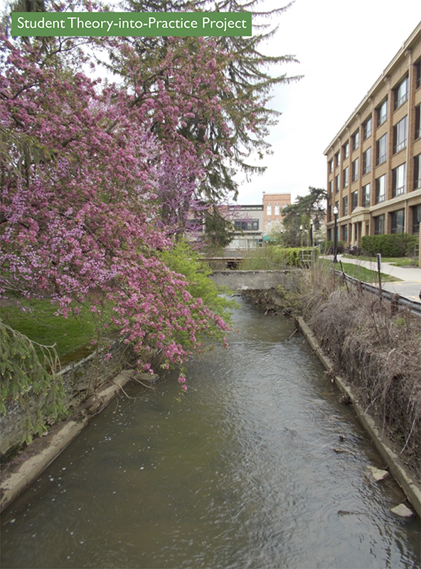
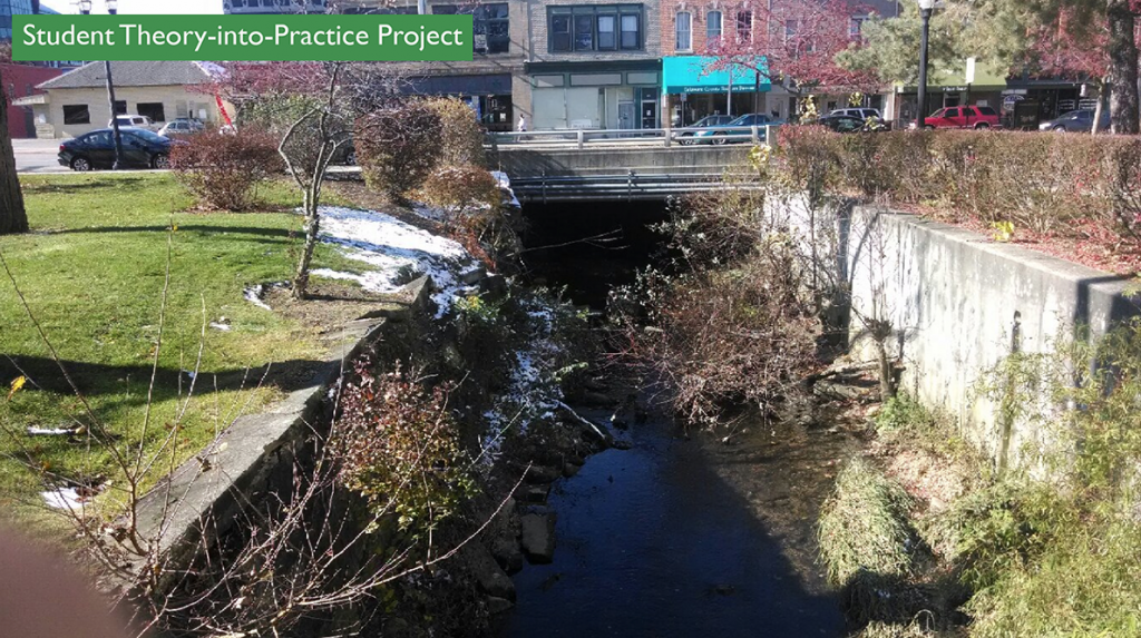
The Delaware Run is small stream, or as in local terms “creek” (often pronounced crik), that runs through the heart of the bustling North Columbus suburban community of Delaware, Ohio. With its location so entrenched in the downtown area of the town of roughly 35,000 people, undoubtedly there have been many changes to its ecological, as well as, its physical features since European settlement began around the turn of the nineteenth century. Today, the Delaware Run is located near the campus of Ohio Wesleyan University and is merely a simple trench that is overgrown with invasive species, has crumbling infrastructure, and in general no longer possesses the natural ability to reach its full ecological capacity.

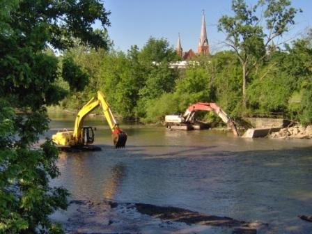
The Delaware Run starts to the west of downtown and ends just northeast of Ohio Wesleyan University’s campus not far from historic Selby Stadium at a confluence with the Olentangy River. Historically, the stream made its way east, and it naturally meandered slightly, slowing the flow of water and allowing for normal ecological functions of a small stream. However, with the march of human progress, the ecological integrity has fallen at the hands of channelization. Today, in large sections of the run, the natural curvatures of the embankments have been replaced with straight cement banks. Also, large portions are no longer visible and have been built over by the expansion of downtown Delaware. These cement banks and elimination of Delaware Run’s natural order has led to an increase in the water’s speed that does not allowing life to flourish. However, now there is the ability to take some corrective action to restore the ecological integrity of the stream as it runs along side the campus of Ohio Wesleyan University.

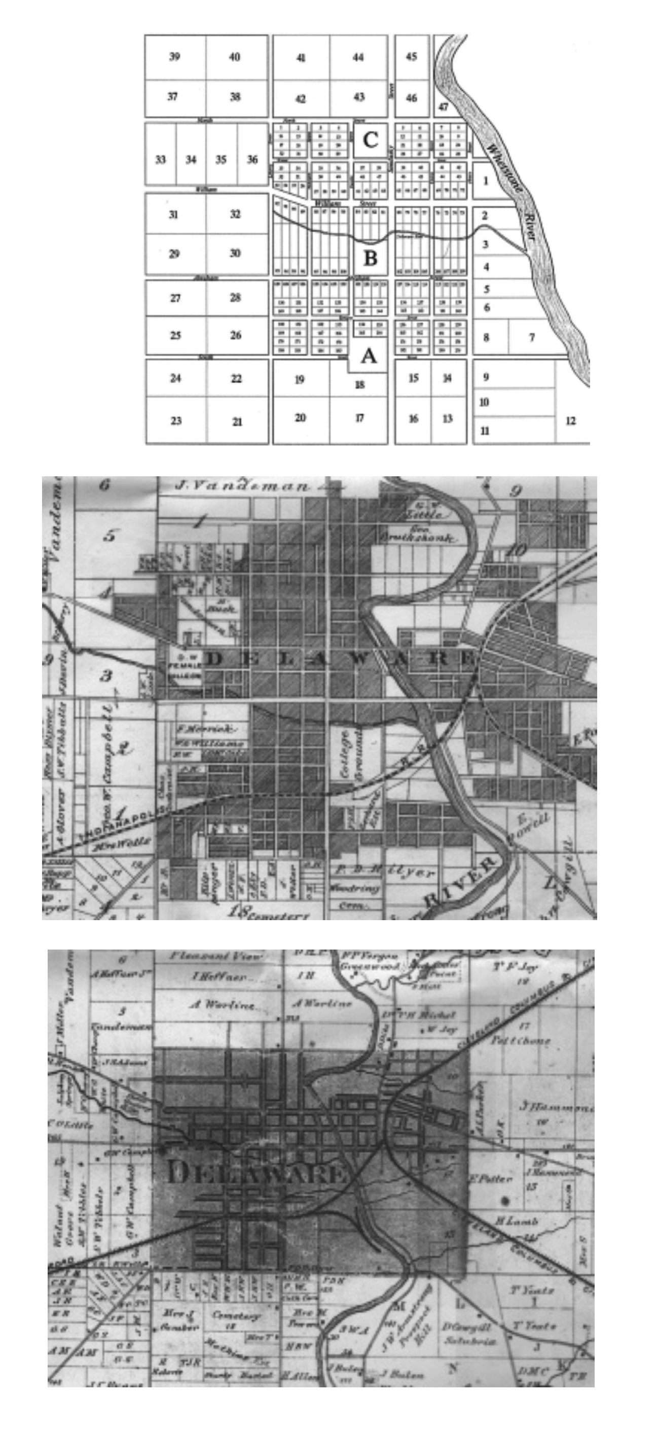
We identified the Delaware Run’s natural path through much time researching through dusty books courtesy of the Beeghly Library Historical Section. We were able to obtain maps from the late eighteen hundreds that showed the natural meandering path of the stream prior to the current channelization and covering of the majority of the stream. In the future, these maps could serve as potential guides for complete dechannelization. Complete opening and dechannelization of the stream is rather ambitious, and it is much more likely that these maps can be used as evidence that the stream did have a natural curvature. They could serve to help dechannelization efforts along Ohio Wesleyan University’s campus.

del_run_maps

Scientific History

In 1993, a study done by Dr. John Gatz and Dr. Amy Harig showed a decline in biotic integrity of the Delaware run over the previous fifty years.   They found that by 1940, the run had already been degraded by human contact. As the population grew from 9000 to 20,000 by 1992, there was an increase in degradation seen at the Run. Agriculture began to increase which caused more runoff and siltation from the chemicals used on the fields. Urban runoff including petroleum products also increased in the Run. Also, the Run began to see a loss of riparian vegetation due to erosion. Habitat loss through channelization was also another issue they encountered in their research.

After looking at the abiotic factors of the run they turned to the biotic factors. There was a clear decrease in certain species of fish found in 1940 and an increase in pioneer species. They concluded that this change in species showed the instability of the environment, because pioneer species are known to inhabit new or frequently changing environments. When looking at the individual fish they found there was an increase in deformities, eroding fins, lesions and tumors from 1940 to 1992.

Another study, completed in 1999 on the Delaware Run, showed an increase in contamination of the water since the 1993 study. Of the selected tributaries in Delaware county, the Delaware Run had one of the highest degrees of metal contamination (aluminum, chromium, copper, and zinc) and organic contamination (phosphorous and sulfur). The metal contamination was the result of polluted runoff from city streets, sidewalks, metallic particles from car brakes, leached materials from concrete, aluminum and copper gutters, and galvanized metal products. Sewage contamination had increased along with pesticide runoff such as Chlordane. E. Coli was also recorded in the run that could have added to many illnesses in Delaware at this time. The natural sulfurous groundwater found in the area seeped into the run and left a whitish precipitate and odor that allowed only tolerant fish and macro-invertebrate communities to thrive in it, however toxic levels hindered many aquatic compounds. After this study, scientists still found that the Delaware run still had a predominance of highly tolerant and pioneering fish species indicating that the environment was still unstable.

FLOW or Friends of the Lower Olentangy watershed did an assessment of the Delaware Run in 2002, and they were able to find more problems that the run was been enduring along with other ecological measurements. The first problem they found was that the run was no longer meeting the WWH (Warmwater Habitat) standards, which it had been in the previous years and studies mentioned above. Scientist believed it could have been done due to the increase in phosphorous, contaminated sediment runoff, habitat modification and sewage. They were able to conclude this by finding only fair fish population and poor macro-invertebrates communities. Species of fish that are environmentally sensitive were lacking in the run while 67% of the fish collected for the assessment were pollution-tolerant species. Bottom-dwelling inverts were of low diversity and were dominated by pollution-tolerant forms such as the black fly larvae and flat worms.

After reviewing three ecological assessments of the Delaware run starting from the 1940s to 2002 it can be easily seen that the problems have become more of an issue through time. Population increase in Delaware has caused more chemical runoff, sewage, and debris to enter the run that then affects the biotic factors that live within or around the water.

Restoration

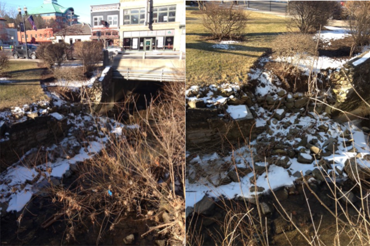
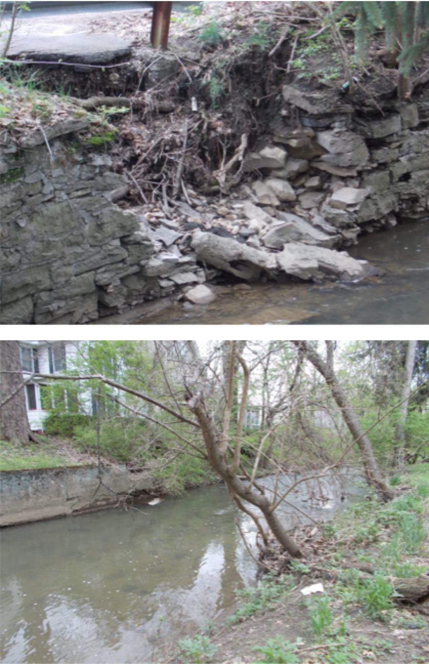
After meeting with Kristen Piper, Watershed Coordinator of the Upper Olentangy, we became aware of what plans the city has for the Delaware Run. Their first order of business is fixing the wall that has collapsed near Sandusky Street. If the wall continues to collapse it could affect the bridge, which the road is built on. The Delaware Run’s banks as they are now do not abide by the OSHA codes. The sides of the run drop off above the maximum required height. In order to fix this, they would need to slope to the south side of the run. Since this area has been channelized for so long, trees located on the banks of the run would need to be cut down. The city has been researching ways of saving the larger trees, however none have been proposed yet. 

Current State of the Delaware Run

The current sate of Delaware Run has several issues that are causing damage to it and endangering the Runs ecosystem. Through diligent management of the area each of these could be solved in turn and the Run ecologically improved to provide better habitat and ecological services.

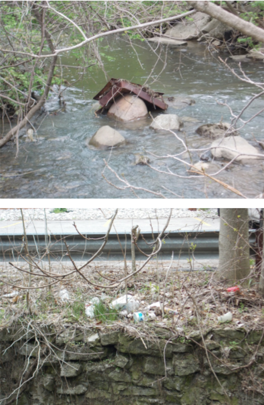
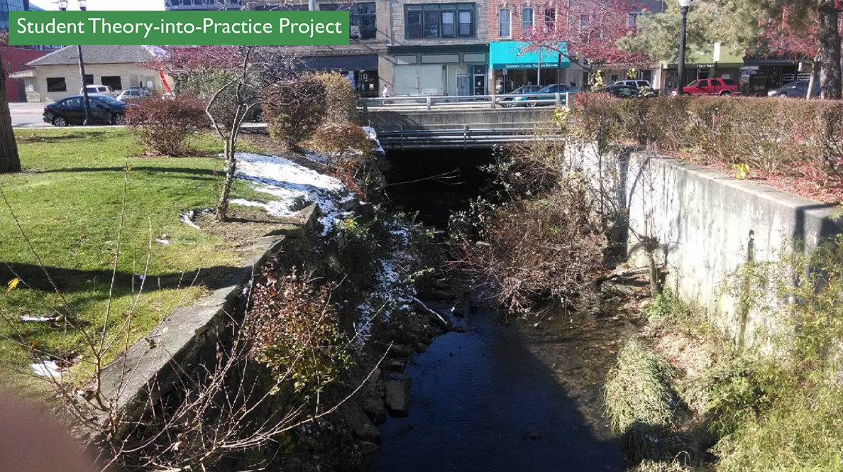
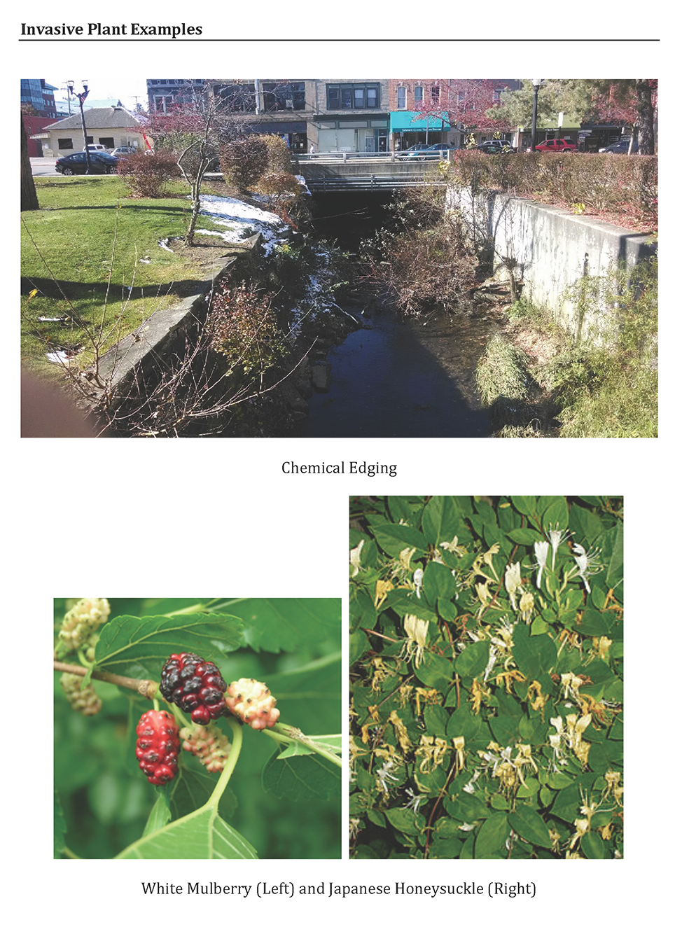
Chemical Edging: The grass of campus runs right up the edge of the wall of Delaware Run. The runoff from this carries chemicals and pesticides that are used in the treatment of the landscape. This Chemical Edging is also the same process used around many of the trees near the run (insert picture). In order to prevent competition and crowding with these trees large amounts of a pesticide is sprayed around them to kill plants and prevent their growth.

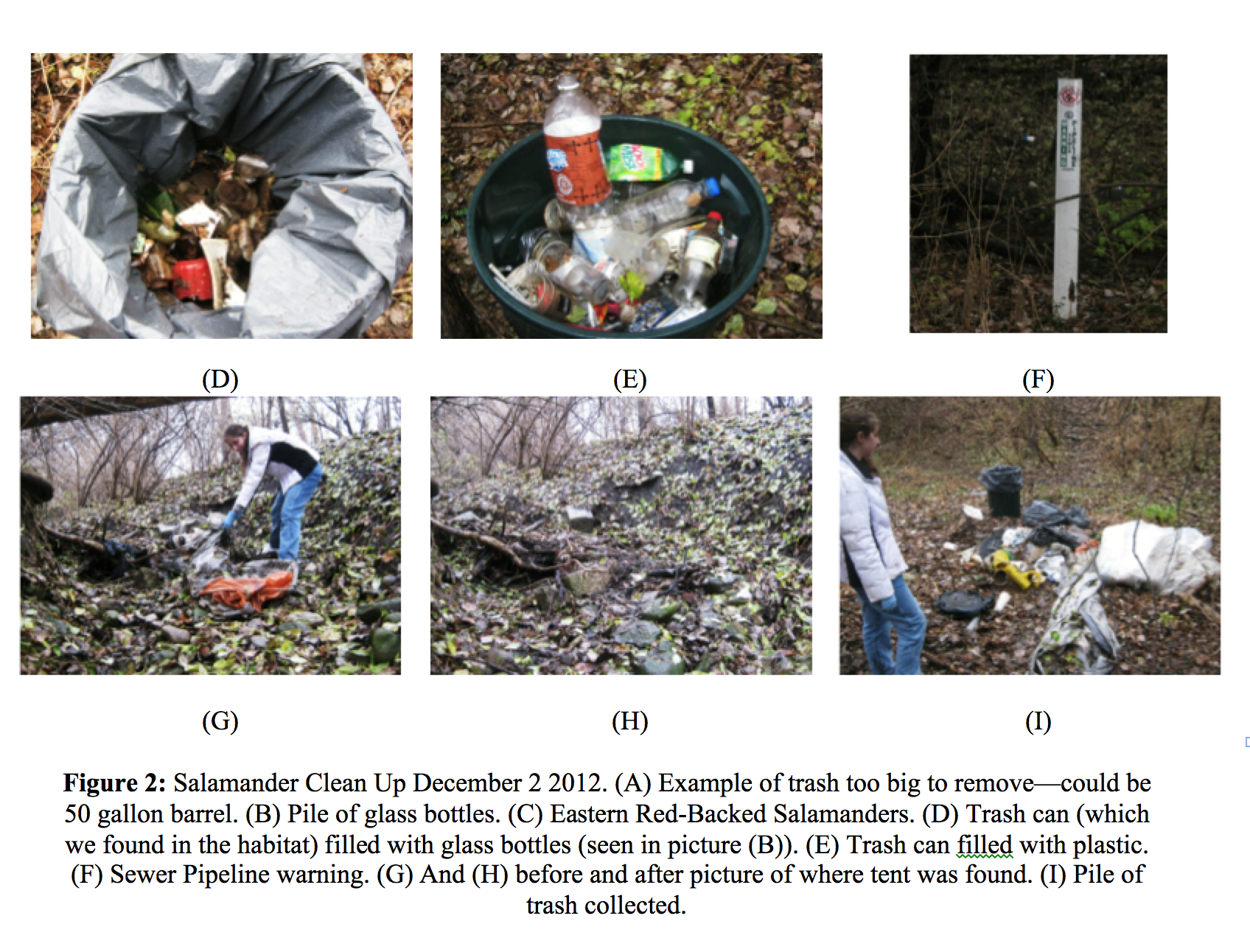
State of the Water; There is a fair amount of algae growth in the water (insert photo) which means there is a high chance that it contains sizable amounts of micro-nutrients. These likely do come somewhat from campus, but most likely this is minimal. The presence of these micro-nutrients at these levels means it is most likely from an upstream source, though more research on this certainly possible. Litter is a consistent presence in the Run on campus, ranging from netting to trash to tires.

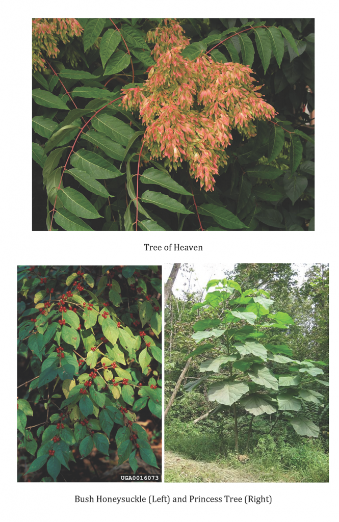
Presence of Invasive Species; There are several invasive species also present at the Run which will require removal and continual management in order to help restore other species. Many of these invasive species are situated upriver along the banks especially in Blue Limestone Park. For example photos see the Invasive Plant Example Section.

del_run_images2

del_run_images3

White Mulberry: This invasive plant is native to northern China, and is the size of a small tree.

Tree of Heaven: Another species from China, Tree of Heaven translates directly to ‘foul smelling tree’. Its name derives from the fact that the tree grows very rapidly.

Japanese Honeysuckle: Native to East Asia, Japanese Honeysuckle is a vine that grows on many different trees and plants. It tends to violently displace them and grows incredibly quickly.

Bush Honeysuckle: Native to the temperate areas of East Asia. This plant is even more aggressive than its vine counterpart. Bush Honeysuckle grows incredibly wide and crowds out anything near it. The limbs, which grow together in bundles from the ground before spreading out, can be nearly as thick as a forearm. The plant secretes a chemical into the soil around it which will actually kill off other plants in addition to its crowding. In areas that are sufficiently overgrown removal of the plant revels that all of the underbrush of a forest area can become honeysuckle, leaving nothing but trees and dirt.

Princess Tree: This tree is native to central and western China. Princess tree is identifiable by its large wide leaves that have a peculiar odor when crushed in your hand. Princess tree crowds out many native trees and is very prolific.

What Needs To Be Done

There are several projects we can do in the short term to help immediately with the Run’s state. A river sweep can be organized in the spring, and if enough people are interested an invasive species clean up can be organized. Though to remove the invasive trees would require professional services as well as some trained in the use of a very specific biodegradable pesticide in order to most effectively remove the Bush Honeysuckle. The organization FLOW has volunteered to help with the river sweep provided we inform them of when we perform it. If they are busy at the time they can also get us in touch with a local group, which can provide supplies.

Goals

Short Term:

  • River Clean Up: teaming up with the Wildlife and Environment Club along with other students from OWU, Delaware Run clean ups will be scheduled; partners will pick up debris that has fallen into the water and around the run.
    • These clean ups can also be a chance for students to remove the invasive species that have covered the banks such as Japanese Honeysuckle and Princess Tree.
  • Ecological Studies can begin immediately to measure the abiotic and biotic factors of the run. At OWU there are professors that teach parasitology, ecology, entomology, and ornithology. The run would allow them place to have field lectures and lab while also monitoring the ecological growth.

Long Term:

Time and resources allowing, the Delaware Run on Campus could become not only a healthy stream environment, but also an outdoor area for classes from the sciences to the philosophy to promote projects from species study to sound ecology. Eventually, provided it is the best option, the Run could even be dechannalized and restored to its previous state.

Recommendations

The cities work in reinforcing one of the bridges over the run will involve sloping one of the banks, one thing that could be done is the terracing of the slope to help with runoff and the placement of native species of plants that will not harm the wall.

Also, while many of the current invasive species can be removed, because they come from an outside source the Run will need to be closely monitored and the species removed when they are identified as growing. Many of the woody plants growing over the run out of the wall and causing damage to the walls stability could be cut.

Political Issues

When examining the short and long-term goals of improving the Delaware Run, political concerns came to light. We found that there were many entities that needed to be consulted before, during, and after the construction process to dechannelize the Delaware Run. The first group would be the city, and perhaps the county of Delaware, because that is where the run is located. The next would be the state due to the historical location of the creek and the issue with water rights. Finally, the national government would have to be involved due to the environmental and ecological changes that would be made to the local environment.

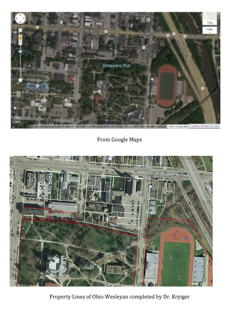
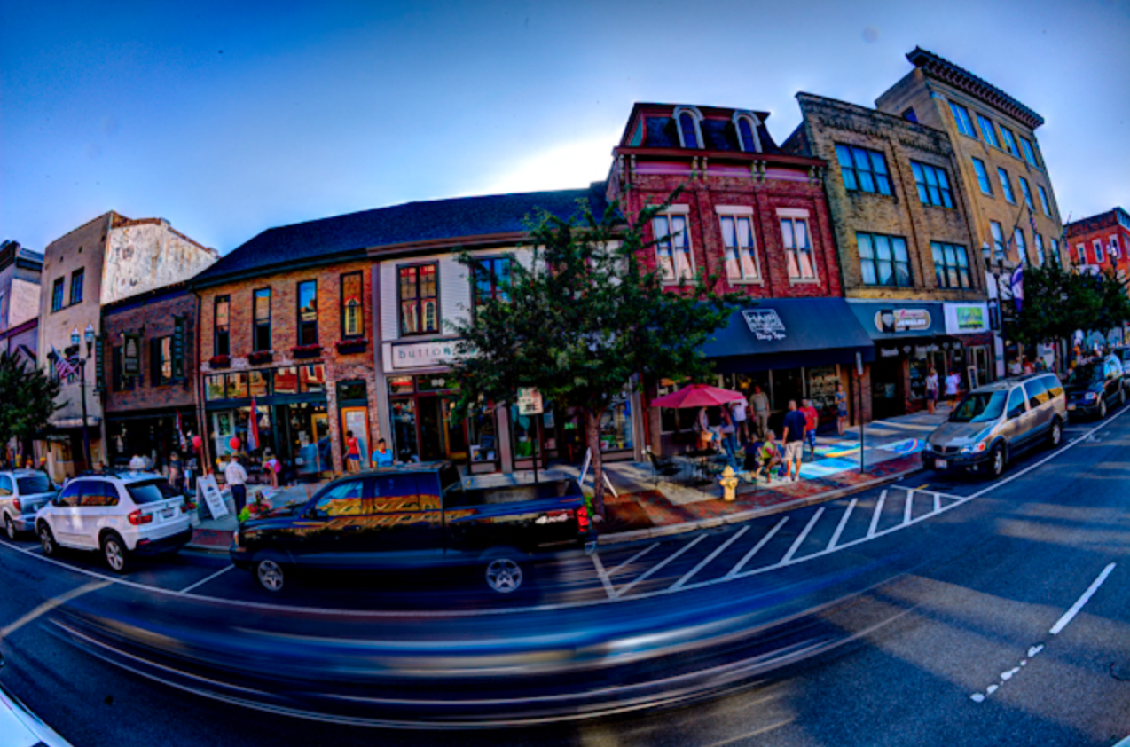
The city of Delaware is the first and main entity that Ohio Wesleyan will need to consult with to dechannel the Delaware Run. This being said property lines needed to be considered. We did research on local property lines, and Dr. Kriyger created a map clearly indicating the location of Ohio Wesleyan property.   We also needed to be concerned about the location of the run due to the fact that it was in an urban area. After meeting with civil engineers, we found that engineering assigned specific standards that needed to be met. The civil engineers determined that structural issues needed to be addressed where a main road runs over the Delaware Run. Also, OSHA safety codes would need to be examined to make sure no one would fall into the water below. The groups that would be overseeing the project would include Delaware City Council, Ohio Wesleyan Buildings and Grounds, local environmental restoration groups, and Delaware’s Watershed Coordinator. All of these groups would work together to manage and make sure no extra damage would be done the ecosystem during the project.

The second group is the state of Ohio and they would be where the permits do to the work on the Delaware Run would be filed. We would have to get approval from the Ohio Environmental Protection Agency (Ohio EPA), the Ohio Department of Transportation (ODOT), the Ohio Department of Natural Resources (ODNR) and a few others to get the green light to work.

Kristin Piper, the Watershed Coordinator – Upper Olentangy provided us with a few resources for this project. They would have to considered and applied for when getting ready to begin on the restoration of the Delaware Run. The resources she gave us included the Olentangy General Construction Permit. It would have to be filled out to maintain a promise of water quality while working our portion of the Delaware Run. Second, we would have to comply with the rules of the Ohio EPA’s Storm Water Program by providing a notice of intent. Finally, we would have to follow the regulations when working with In-Stream Construction Activities. The time for the construction would have to be from July 30 to April 15, therefore we would be limited on the length of the project. Furthermore, an assessment of other state laws would have to be considered to be sure we would not be violating any other regulations.

Similar legal factors transcend from the state level to the federal level. Permits and approvals would have to be filed, especially when the design plan is drafted. Construction on a water area need approval from the Environmental Protection Agency (EPA), the United States Fish and Wildlife Service, the Department of Natural Resources, and many more. Specifically, the Clean Water Act would definitely be taken in to high consideration for the duration of the project.

Also our legal research continued, we discovered the NRCS-USDA’s Stream Restoration Handbook. It is a nationally published handbook on understanding streams and how to do restoration. There are many helpful details within its pages but to read the book in detail would take a substantial amount of time and knowledge that only an expert would have. It did hint at laws that we would have to follow including section 404 of the Clean Water Act, section 10 of the River and Harbors Act, state section 401 of Water Quality Certification, and section 106 of the National Historical Preservation Act. Also, after completing the stream design we would have to submit them to the right agencies as specified in the handbook on 654.17, which gives further information on the required criteria. The criteria includes discharge recording, wildlife assessments, and holding a public hearing to give information about the project at hand, and acquirement of all the correct permits before construction begins.
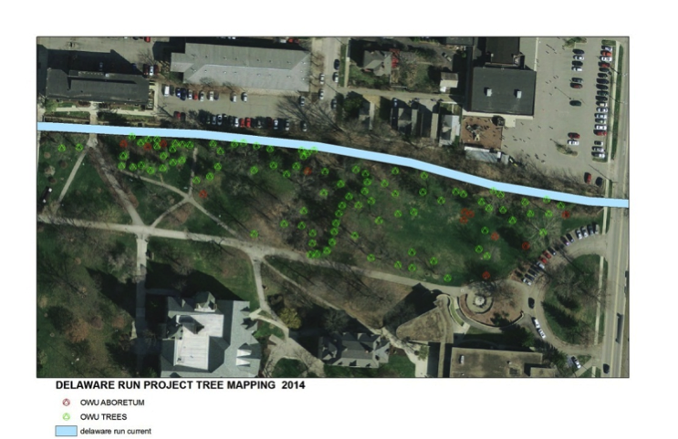
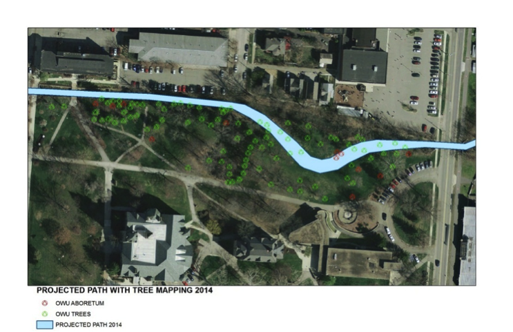
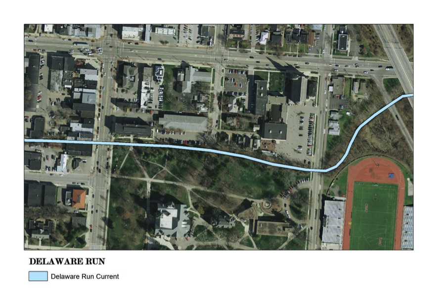
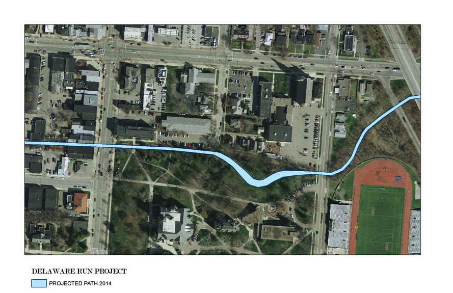
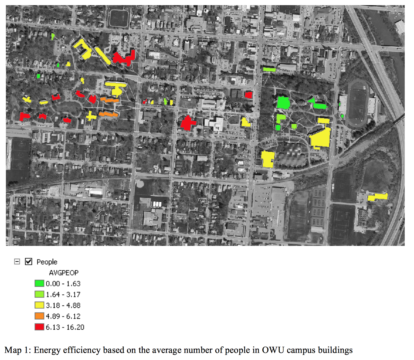
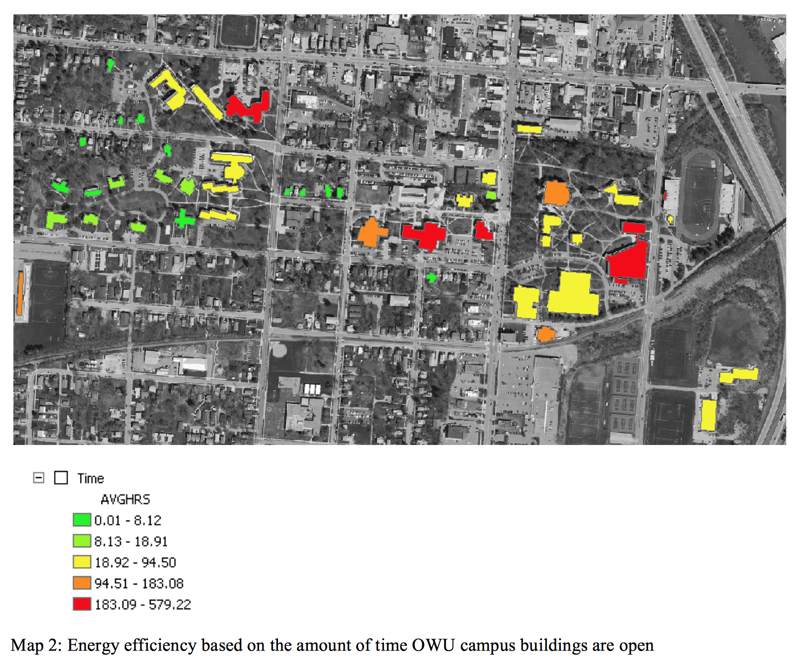
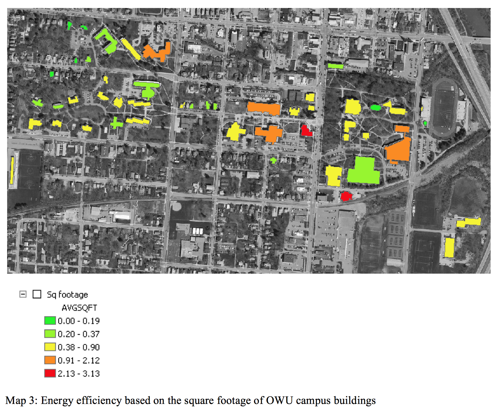
Maps

Below are maps of the Delaware Run’s natural course and Ohio Wesleyan University’s current property lines.

del_run_images1

DIY Food Workshop

Making and eating food is one of the most socially and biologically important human activities. Making healthy food is much easier, and more fun, than most students think. In order to encourage social DIY cooking on campus, with an emphasis on healthy eating, we developed a DIY Food Workshop. The workshop covered basic cooking skills and healthy DIY food options, with an emphasis on interaction and engagement. The event ends with a meal, consisting of foods prepared during the workshop. The first workshop was held in the spring of 2012.

diy_cooking

Making and eating food is one of the most socially and biologically important human activities. Making healthy food is much easier, and more fun, than most students think. In order to encourage social DIY cooking on campus, with an emphasis on healthy eating, we developed a DIY Food Workshop. The workshop covered basic cooking skills and healthy DIY food options, with an emphasis on interaction and engagement. The event ends with a meal, consisting of foods prepared during the workshop. The first workshop was held in the spring of 2012.


DIY Food Workshop

Date: April 2012

This workshop may be offered again if there is interest. Please contact John Krygier if you are interested in holding another DIY food workshop.

Project research, organization and planning: Olivia Gillison (project for Geography 360: Environmental Geography & Independent Study).

Guest Chef: Del Stroufe, Chef & Educator, Wellness Forum Foods, Columbus OWU Chefs: 5 OWU faculty, staff, or students with cooking skills to assist

Event Publication: OWU Eating Green Map, Guide, and Cookbook: Includes information on student-accessible kitchens, sources of ingredients, cooking glossary, basic kitchen tools and ingredients to have on hand, and suggestions for cooking & eating social events.

1. Talk: Introduction (30 minutes): Del Stroufe provides an overview of DIY cooking and healthy eating, and an introduction to the workshop.

2. Talk: DIY Cooking on Campus: the Facts (30 minutes)

  • available kitchens & cooking tools
  • portable cooking setup (camp stove, etc.)
  • local / organic food options
  • buying ingredients from Chartwells with food points
  • off campus food purchase options
  • encouraging healthy DIY social cooking & eating

3. The Menu & Preparation (2 hours)

  • Smith: drinks but don’t eat other food!
  • Minimize bothering staff: Dan Magee
  • participants split into groups of 4 (10 groups max)
  • five dinner courses: workstation for each: soup, stir fry, pasta, pizza, dessert (fruit crisp)
  • workstation: preparation of ingredients, assembly, cooking

3a. Basic food preparation skills

  • hands-on experience with skills needed for workshop cooking

3b. Food assembly and cooking

  • each group of participants experiences each workstation

4. Eating & Future Workshops (focused on different recipies, cooking skills, global cuisines, etc.)


Workshop outline & booklet (PDF): DIY Cooking: Do-It-Yourself Cooking Workshop for Students 

Building Energy Monitoring and Analysis

A student theory-into-practice project focused on processing, analyzing and mapping energy data for the Ohio Wesleyan campus. A significant part of the project focused on the development of an equation so that the relative energy efficiency of buildings on campus (which vary widely in size, usage, age, etc.) could be compared.

energy_header

A student theory-into-practice project focused on processing, analyzing and mapping energy data for the Ohio Wesleyan campus. A significant part of the project focused on the development of an equation so that the relative energy efficiency of buildings on campus (which vary widely in size, usage, age, etc.) could be compared.


Building Energy Monitoring and Analysis

Ohio Wesleyan University and Delaware, Ohio Sustainability Region

August 2012

Silas Jolliff, Adam Pinkerton, Jon Rux, Mason Tice, Keegan Varner, John Krygier, Sean Kinghorn

Summary

The purpose of the Energy Monitoring and Analysis project was to process energy data and create a map showing energy usage and efficiency on the Ohio Wesleyan campus. The map displays energy use and efficiency in relation to building hours, building size, and number of people per building. The data is, then, normalized to take into account important differences from building to building. This map is based on the most recent full-year utility data (2010) and has the ability to be updated annually as new data becomes finalized. Proposed developments include real-time utility monitoring (in addition to data from utility bills), the inclusion of City of Delaware-owned buildings (and other public buildings) in the project, direct feeds of utility data into a database for the sustainability region, and access to and display of the data in a real-time interactive map linked to the sustainability region database.

This map will help raise awareness of the patterns of energy usage on campus for students, faculty, prospective students, and alumni. It would also be of use to school administrators when determining where to focus efforts to improve the school’s environmental footprint. As the project spreads to off-campus buildings, similar impacts can be expected. Students, city employees, and others can experiment with energy reduction strategies and document pre- and post-experiment utility usage, thus providing significant empirical evidence for evaluation and assessment.

Methods and Results

OWU utility data was acquired from the OWU Sustainability coordinator, Sean Kinghorn, for a majority of the buildings on campus. The data was normalized using three separate methods:

  1. Average kWh per person
  2. Average kWh per hour of operation
  3. Average kWh per square foot

For the residential side, we isolated the utility data and extracted the buildings that were not in use or had since been removed. This data was coded using street addresses, so we used Google Maps to locate buildings and come up with the building names recognized by OWU. We also had to take monthly averages for the utility data to account for summer and incomplete months. Next, we developed a methodology to normalize the data. The average kWh per person was calculated based on a housing count from the OWU Residential Life office for the two academic semesters included in the data. Because the number of inhabitants changed between semesters, we took an average of these two numbers. We then divided the monthly average electricity usage by the number of inhabitants. The Average kWh per hour of operation was based on results from a campus-wide survey we undertook. The survey found that students spent an average of 14.74 hours in their dormitory, fraternity, or SLU. Next we divided the monthly average electricity usage by the 14.74 statistic. Lastly, average kWh per square foot was calculated with building data acquired from Sean Kinghorn. Finally, we divided the monthly average electricity usage by the gross square footage.

To obtain data for the academic side of campus we started by analyzing utility data given to us by Sean Kinghorn. We had monthly totals for total electricity consumption in kilowatt hours (kWh). To make this data more accessible to the general public, we normalized the data in a manner similar to the residential side. We started by data scraping class lists from the OWU Self Service website. Importing the data to Excel, we then took the total number of people for each building and multiplied it by 2.5 to obtain a weekly number per building (this was assuming an even distribution of 3 day per week and 2 day per week classes). We then took this total and multiplied it by 4.21, or the average number of weeks per month. This gave us the monthly average of students per building. We also determined the average number of faculty per month, per building, considering faculty spend far more time in the buildings than students. After obtaining the numbers from the OWU website, we multiplied them by 5, assuming 5 office days per week, and then again by 4.21. Combining these two totals, we had an estimate of the number of people in each non-residential building. We then divided the number of people per building per month by the energy consumption per month, giving us our monthly average.

We then looked at the gross square footage of each building. We found the size of each building in the utility data provided to us. To determine the efficiency of each building in relation to its size, we simply divided the size of the building, in square feet, by the energy consumption per month.

Finally, we found building hours for as many buildings as possible. Some buildings were found by contacting the Public Safety office, while others were found manually. We found the hours for approximately 90% of all buildings on campus. As with the other buildings, we took the posted hours and multiplied them by 5, and then by 4.21, giving us a monthly average of hours spent open. We then divided the monthly average by the energy consumption per building.

In general, the data variables we chose and methods used to collect the data should be critically reviewed by experts in building utility efficiency and adjusted to more adequately reflect efficiency criteria. However, we believe we have established a valid approach to generating energy use and efficiency data that allows for valid building-to-building comparisons.

Finally, we imported the data into ArcGIS. To do this, we had to convert our spreadsheet data to a DBF file, then join it with an attribute table in ArcGIS. We picked the simplest parameter we could, Building Code, and then matched the two files up manually, editing the attribute table as we progressed. Once finished, we joined the tables in ArcGIS and created a series of maps. The classification (categorization) of the data on the map is based on generic map classification schemes, and should be adjusted to match external criteria for assessing building energy efficiency. See Appendix A: Maps for examples of the maps that can be generated.

Recommendations

  1. An expert in building energy efficiency should evaluate our methodology for normalizing building energy use and efficiency, as well as the classification of the data on maps (to match external criteria for assessing energy efficiency).
  1. Acquire building utility monitors for more buildings and establish direct links from utility monitors in buildings to a database for the sustainability region. Establish direct links from digital data sources of the other variables (student, faculty numbers in buildings, hours, etc.) to the database when possible to maintain accuracy of the normalized data.

Building Utility Monitors: The OptoEMU Sensor Energy Monitoring Unit

Information: http://www.opto22.com/site/pr_details.aspx?cid=1&item=OPTOEMU-SNR-3V

Cost: X units at $1,295 per unit: = $XXXX total

  1. Extend the utility monitors and data normalization methods to City of Delaware buildings and analyze and map the data in a manner similar to what was done with campus building utility data.
  1. Develop energy reduction and efficiency projects that can be documented with the normalized real time utility data available in the Sustainability Region database and mapping software.

Appendix A: Maps

Map 1: Energy efficiency based on the average number of people in OWU campus buildings:

Screen Shot 2014-10-20 at 6.05.56 AM


Map 2: Energy efficiency based on the amount of time OWU campus buildings are open:

Screen Shot 2014-10-20 at 6.09.21 AM


Map 3: Energy efficiency based on the square footage of OWU campus buildings:

Screen Shot 2014-10-20 at 6.09.34 AM


See the full PDF report here: Building Energy Monitoring and Analysis

Continue reading “Building Energy Monitoring and Analysis”

New Course: Sustainability Plan Practicum: Spring 2014

Dr. John Krygier, Director of Environmental Studies and Professor of Geography, is offering a practicum (Geography 499) focused on researching and creating a draft Sustainability Plan for Ohio Wesleyan University during the Spring semester, 2015.

greenowulogo

Dr. John Krygier, Director of Environmental Studies and Professor of Geography, is offering a practicum (Geography 499) focused on researching and creating a draft Sustainability Plan for Ohio Wesleyan University during the Spring semester, 2015.

Students will be working with faculty and staff on the Sustainability Task Force (STF) as well as using professional and academic sources to create the draft plan.

Rock Jones has expressed interest in having OWU sign the American College and University Presidents’ Climate Commitment. This Commitment involves many of the issues that would be included in a sustainability plan for campus.

The course is scheduled for Tu/Th 10-11:50 but will leave open the option to arrange a different meeting time, depending on who takes the course.

For more information, contact Dr. Krygier.

Sagan National Colloquium 2014: Water in our World

This year, the Sagan National Colloquium will celebrate its 30th anniversary with a new series, H2OWU: Water in Our World.

sagan_water

This year, the Sagan National Colloquium will celebrate its 30th anniversary with a new series, H2OWU: Water in Our World. We will welcome to campus a broad, multi-disciplinary set of visitors and speakers that allow students to see the many different ways that water affects the world and that water can be studied, discussed, and transformed. By bringing in scholars and activists from many fields, the SNC will link human, geological, and environmental pasts, presents, and futures in compelling and interesting ways.

Schedule: http://snc.owu.edu/schedule.php

More information: http://snc.owu.edu

Twitter: https://twitter.com/SNCatOWU

11th Annual Olentangy Watershed Forum 2014: Protecting and Restoring our Water Resources

For the past 11 years, the Olentangy Watershed Forum has connected citizens and experts who wish to explore issues that impact the quality of life in the watershed.

????????????

Removal of low-head dams on Olentangy River, near Delaware (2011). Source.

11th Annual Olentangy Watershed Forum 2014: Protecting and Restoring our Water Resources

Organized and Sponsored by

olentangywatershedforum

For the past 11 years, the Olentangy Watershed Forum has connected citizens and experts who wish to explore issues that impact the quality of life in the watershed.This year’s agenda is filled with professionals who will speak on topics pertaining to the protection and restoration on the Olentangy Watershed. Confirmed speakers include:

  • Tom Curtin: Preservation Parks’ Initiatives in the Olentangy Watershed
  • John O’Meara: MetroParks’ Olentangy Trail Expansion
  • Ben O’Dell: USACE’s Delaware Dam Management Issues

Plus reports from the Olentangy Watershed Coordinators, Del-Co Water and Preservation Parks.
After a networking lunch, you can go on a canoe tour of the scenic Olentangy River or take a tour of the Olentangy Caverns.

This forum is for local residents, water resource professionals, township officials, landowners, and farmers who want to learn about water quality issues in the Olentangy Watershed and what effective planning strategies can be employed.

When: Thursday, October 16th, 2014 from 9:00 am – 3:10 pm. Doors open at 8:00 am. Where: Del-Co Water, 6658 Olentangy River Road, Delaware, Ohio 43015

Come and get an update on all the initiatives in the Olentangy River. Why is this important? The river serves as our drinking water supply, provides recreational relief from the urban environment and is an essential link for wildlife survival. The more you know, the more you can help protect the Olentangy.

Forum Specifics: There is no cost to attend the Forum thanks to our event sponsors. However, registration is required and seating is limited. Walk-ins will be accommodated if space is available. Lunch will be provided.

Registration: Pre-registration requested by Monday, October 13th. For more information or to register, please contact Erin Thomas at ethomas@delcowater.com or 740-548-7746 ext 2221

Press Contact: Laura Fay
Secretary, Friends of the Lower Olentangy Watershed
614-580-2656